- Play
- Shopping
- Antiques
- Boutiques and Unique Shops
- Groceries
- Sporting Goods & Outdoor Gear
- Retail
- Arts & Culture
- Scenic Drives
- Community Recreation Center
- Outdoors
- Museums
- Museum of the Mountain West
- Montrose Historical Museum
- Ute Indian Museum
- Historical Sites and Tours
- Black Canyon National Park
- Camping
- Rock Climbing
- Hiking
- History
- Outfitters & Guides
- Activities
- Hiking
- Fishing
- Golfing
- River Rafting & Kayaking
- Rock Crawling
- Astronomy
- Biking
- Mountain Biking
- Road Biking
- Camping
- Rock Climbing
- Horseback Riding
- Hunting
- Water Sports Park
- Off-Roading
- Birding
- Winter Activities
- Skiing and Snowboarding
- Snowmobiling
- Snowshoeing and Cross Country Skiing
- Ice Climbing
- Fat Biking
- Colorado National Parks Loop
- Wilderness Areas & Parks
- Curecanti National Recreation Area
- Dominguez-Escalante National Conservation Area
- Gunnison Gorge National Conservation Area
- Owl Creek Pass and Silver Jack Reservoir
- Ridgway State Park
- Uncompahgre Plateau
- Grand Mesa National Forest
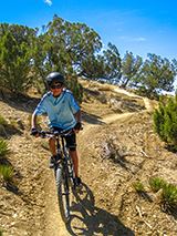
Mountain Biking
The public lands adjacent to Montrose have numerous mountain bike routes in three general geographic areas:
Gunnison Gorge National Conservation Area
The GGNCA is located northeast of Montrose and encompasses the area commonly referred to as the Adobes, as well as rocky pinyon and juniper uplands, and, of course, the deep wilderness canyon of the Gunnison Gorge itself.
Numerous mountain biking opportunities are available along the entire western flank of the NCA. For those seeking a technically challenging singletrack ride, Sidewinder Trail runs 20 miles from the North Sidewinder Trailhead south to Eagle Valley Trail near the Peach Valley staging area. Another access point near the end of the Bostwick Park Road is Kurt’s Trail. Check out BLM’s Flat Top-Peach Valley Trail Map for more detailed information.
The NCA is interlaced with many trails, and some are unsuitable for mountain biking – mostly because they are too steep. The best seasons to ride these trails are spring and fall. Avoid these trails after heavy rain.
Dry Creek Area
These trails are located in the canyon/mesa country west of Montrose. The main trailhead for the area is the Tabeguache Trailhead at the north end of Shavano Valley Road. Access to riding is also possible from Transfer Road. Spring and fall riding season.
Uncompahgre Plateau
These trails are located in the high country southwest of Montrose. Most of these trails are accessible from the Divide Road by way of Dave Wood Road and Highway 90. Summer and early fall riding season. Popular routes include Aspen Trail, Buck Trail, and the Buzzard Gulch Trail System.
Top Four Rides in Montrose
Check out the top four rides recommended by our local mountain biking enthusiasts:
Sidewinder Trail
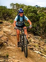
This is the area’s premier trail, dwarfing all but the mighty Tabeguache Trail in scale. Be prepared for tough riding in a remote setting.
Distance: 20+ miles of excellent singletrack! Loops and out-and-backs between 8 miles and 40 miles are possible.
Elevation: 5300 – 6000 feet
Rating: Advanced to Expert
Time: 2 to 8 hours
Map and additional information
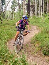
Lower Spring Creek
Ride the gradually ascending (one-way) singletrack trail 8 miles, turn around and bomb back down Spring Creek Canyon.
Distance: 16 miles
Elevation: 6500 – 7800 feet
Rating: Advanced
Time: 3-4 hours
Video
Map and additional information
Buck/Dry Creek Trail
Follow a mix of narrow singletrack and old roads converted to singletrack winding in and out of aspen groves, dark timber, and clearings. At its most northern point the trail climbs to “The Knob” for an outstanding view.
Distance: 10 miles
Elevation: 8900 – 9700 feet
Rating: Intermediate
Time: 2 hours
Map and additional information
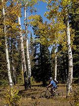
Aspen Loop
This is a nice short ride through beautiful aspen groves. Stop to enjoy an overlook of Lone Cone and the western San Juan Mountains.
Distance: 6+ miles
Elevation: 9,500 – 9700 feet
Rating: Intermediate
Time: 1-2 hours
Map and additional information
Related Links
- National Forest Trail Map
- National Forest Website
- National Forest Mountain Biking Trails - Uncompahgre Plateau
- National Forest Mountain Biking Trails - San Juan Mountains
- COPMOBA Trail Maps
- Local Bike Routes & Trails Map
- Montrose Interactive Bike Map
- Trailhead Map with Lat/Lon
- Colorado Department of Transportation Bicycling Map and Info
- Ridgway Area Mountain Biking Trails Info (COPMOBA)


